Why Are Data on the Stock of Wind Turbine Generators (WTG) important?
Data of existing plants for renewable electricity generation play an important role in the description of the energy system. From the historical development, forecasts for the future can be derived (scenario development).
Where to Find Data on the Stock of WTG?
- Schleswig-Holstein: Open Data Portal SH
- Niedersachsen: Energieatlas Niedersachsen
- Hessen: Hessisches Länderinformationssystem Anlagen (LIS-A) – © Hessisches Ministerium für Umwelt, Klimaschutz, Landwirtschaft und Verbraucherschutz
- Bayern: Energieatlas Bayern
- Baden-Württemberg: LUBW – Landesanstalt für Umwelt, Messungen und Naturschutz
- Saarland: Geoportal Saarland
- Bremen: MetadatenVerbund
FfE Data on the Stock of WTG
Using the above-mentioned open sources and further sources, various data on existing and planned WTG in Germany were compiled at the FfE (see Figure 1). In addition to the installed capacity and the location of a turbine, there is information on rotor diameter, hub height and the year of commissioning. The latter was synthesized in case of data gaps.
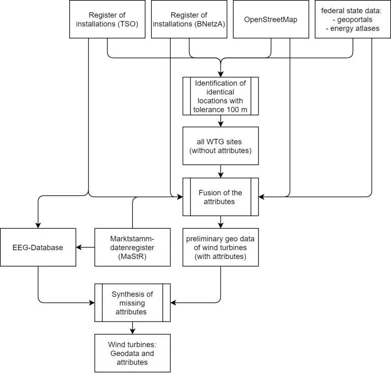
Figure 1: Unification of different data sources and synthesis of missing attributes generates the FfE dataset on WTG.
By synthesizing the year of commissioning, the temporal development of the stock of WTG in Germany can be traced. The expansion and installed capacity since the year 2000 are shown in Figure 2. Deviations from national statistics (like DWG) result from the synthesis of attributes of individual WTG. In 2019, about 54 GW of wind power capacity was installed in Germany.
Figure 2: Temporal development of the stock of wind turbine generators in Germany since 2000.
Where are WTG in Germany located?
In addition to the time component, the geodata of the WTG can be used to determine where how much capacity is installed. Factors that influence the spatial distribution of WTG are wind speeds, available areas, e.g. depending on distances to residential areas, and other regulatory conditions of the individual administrative units.
In Germany there are 96 spatial planning regions (“Raumordnungsregionen”). Within these regions spatial planning authorities designate areas for the construction of WTG taking into account local conditions. Data on the designated areas can be found in the regional plans.
Figure 3 shows regional characteristics based on geodata of WTG and designated areas aggregated to spatial planning regions. These data are provided in the related dataset at the end of this post.
Layers
Number of WTGInstalled capacity of WTG
Designated areas for wind energy
Share of WTG in designated areas
Unit: WTG/km2
≥0.001 to <0.120
0.121 to <0.240
0.241 to <0.360
0.361 to ≤0.482
Layers
Number of WTGInstalled capacity of WTG
Designated areas for wind energy
Share of WTG in designated areas
The highest density of wind turbine generators can be found at the North and Baltic Sea coasts due to high wind speeds. There are also high densities in the federal states of Niedersachsen, Brandenburg and Sachsen-Anhalt.
Europe: © OpenStreetMap contributors | German Federal States & Spatial Planning Regions: © GeoBasis-DE / BKG 2017 | Generalization: FfE e.V.
Europe: © OpenStreetMap contributors | German Federal States & Spatial Planning Regions: © GeoBasis-DE / BKG 2017 | Generalization: FfE e.V.
The highest density of wind turbine generators can be found at the North and Baltic Sea coasts due to high wind speeds. There are also high densities in the federal states of Niedersachsen, Brandenburg and Sachsen-Anhalt.
Figure 3: Cartographic visualization of various data about wind turbine generators and designated areas for wind energy in Germany per spatial planning region. (Move your mouse over the regions to see absolute values)
Further Use of the Data
The stock of WTG and geodata of designated or other suitable areas for the construction of WTG are input data for the FfE Wind Scenario Tool (WiSTl) to calculate capacity potentials within this areas. Other suitable areas are calculated by a GIS analysis (“Weißflächenkartierung”), whereby distances to residential areas can be varied. Such analyses are, for example, a basis for the German network development plan (Netzentwicklungsplan).